It is important to note that in more than one instance, the polystrate plant fossils not only cut through multiple layers of strata but also layers which are further cross-cut by other fossils.
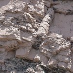
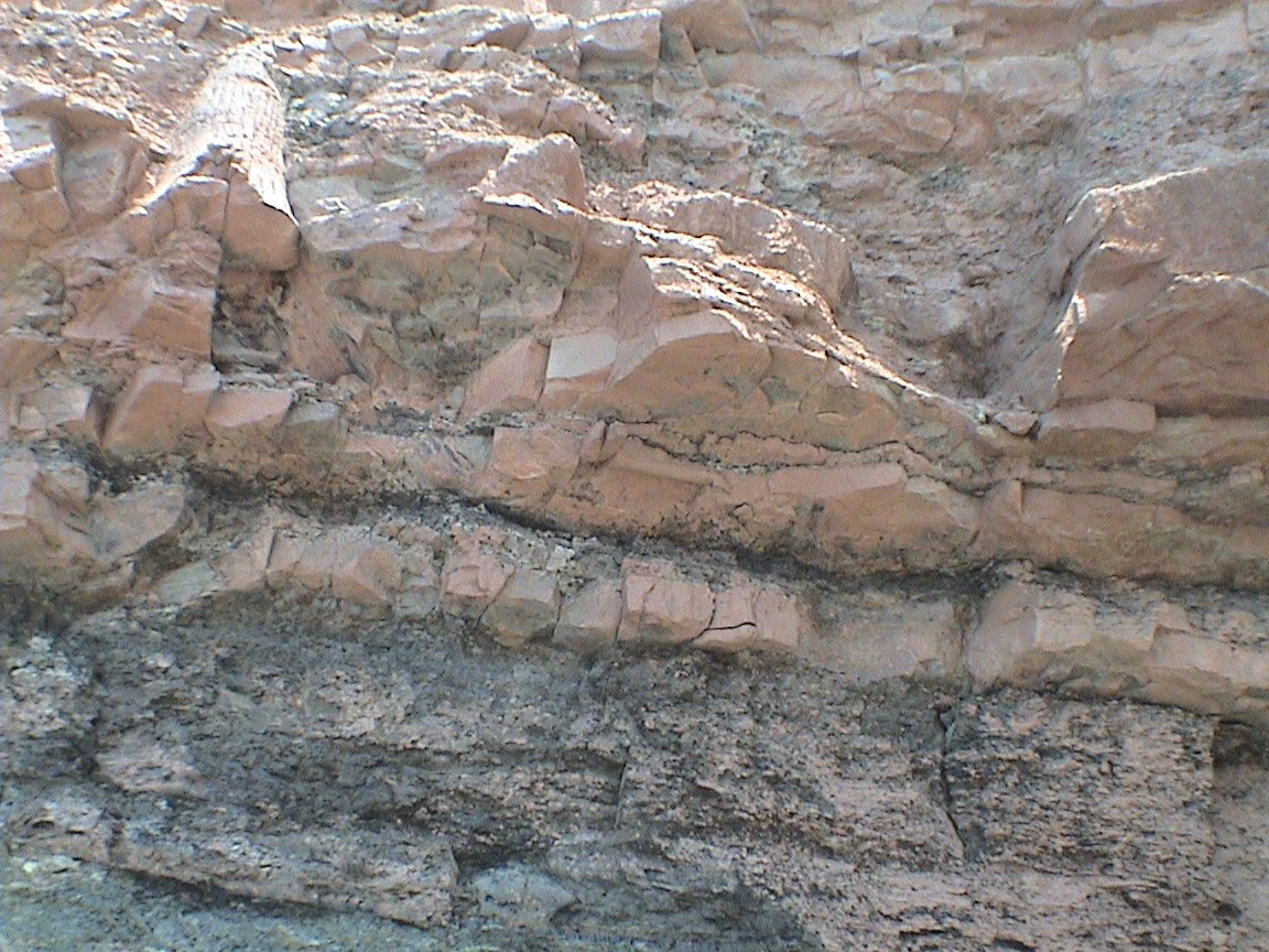
Click on the image for the unmarked, full resolution photo. This is site 12 on the map.
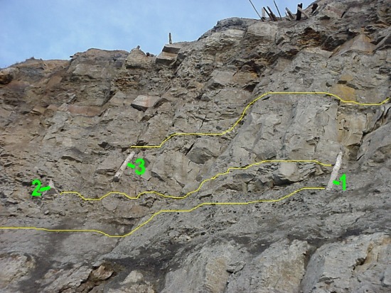
In this example you can see the first lycopod starts (or at least becomes visible, it presumably continues on down through deeper strata in behind the rock) below the second, but ends above it. The second lycopod overlaps both the first and third lycopods, the third one being exposed at least a further 5 meters or more higher than the bottom of the first.
It is very difficult to photograph fossils, and this is one of the reasons drawings and descriptions are still so important in a fossil study. The guidelines drawn in, although they may not look it, trace the strata which are roughly uniform and parrallel. The breaking up of the cliffs creates the bumps and edges which make it difficult to follow the strata. The lycopods themselves (in this photo, not the high-resolution one) have also been highlighted for better contrast and visibility.
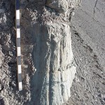
Remembering these are reeds and not logs, how long do you think they would last before succumbing to rot? A year? maybe two? One would think that after a year they would at least collapse and no longer remain vertical. It would appear that these three lycopods were buried quickly, one after the other. The 5 meters or so of rock would have been accumulated quickly, certainly a year or less, not tens, hundreds, thousands or millions of years.
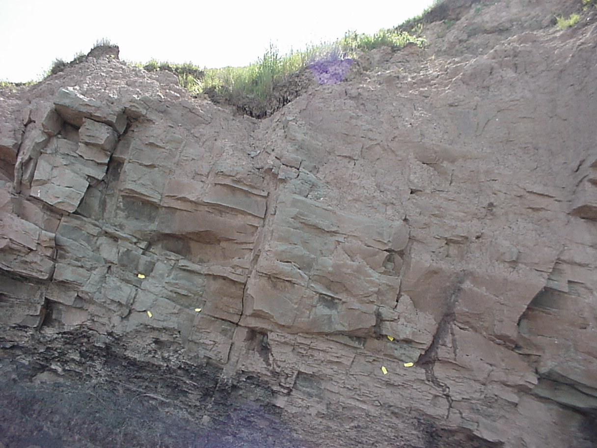
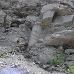
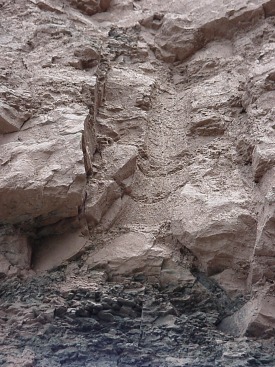
In the same respect, these giant horsetails (again, a reed, and one that still exists today in a much smaller form) are located at site 2, just Northeast of the stairway entrance.
The calamites have been highlighted here for easier identification. Calamite at point A continues on into the rock, the one at point B goes in behind the rock and comes out again at point C. Point D is the photo below. Point E goes into the rock and emerges at point F.
Although only cross-cutting about eight feet worth of strata, it is important to note that these plants were buried within a short amount of time of each other, or at the same time in one giant slurry of mud.
Other interesting artifacts:
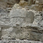
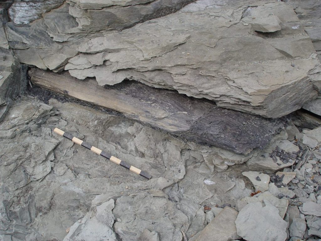
There were two layers of compressed, fossil sea bed. It can be identified by looking for the miriad of small (typically 3-5 mm across) leaves, fish scales and sea shells. The coal seams do not have this. You will also find chunks of the strata on the beach, such as this one.
The seams vary in thickness around the 16″ mark. They are located at points 9 on the map. I think it very important to note that although I looked intently, I did not find one fossil cutting vertically through either of these layers, nor had anyone else that I could find. (Mind you, the people I asked hadn’t seen the inverted trees either)
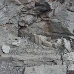
Also noteworthy to visitors are two drainage tunnels which are remnants of the previous coal mining operations. These drainage tunnels are located at point 11 and around point 13
.
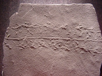
Again, one has to ask: How could these be formed? Proposals that I have heard of the water gently washing in and covering up the tracks, thus protecting them, are just too impossible to me. Two waves would certainly be enough to wash away any track. If it were harder clay it may need some more working, but reality is these tracks had to have been formed (once again) rapidly! One strata in particular, near point 3, had myriads of these fossil trackways. Some of these rocks had fallen to the beach and when split open were full of trackways on nearly every layer. The most likely explanation is once again, a rapid formation. A mud which chemically hardens (not unlike concrete) would be the best candidate for preserving fossil tracks.
But it would have to harden quickly or else the tracks would be lost to erosion.
There have been several animals found in the base of the hollow lycopods, which were then buried inside as the plant infilled. The plant and the encased animals later became petrified.
It had been suggested that these plants grew, and were buried in situ. As the plant died, the top broke off, leaving of course the hollow trunk. Animals had then fallen into the trunk, to eat others which fell in or to be eaten themselves. Eventually the trapped animals or remains were buried inside the trunk, all of which later became petrified. Up to seventeen skeletons had been found in one trunk!
Initially I felt this was a good hypothesis, and even a possible evidence in favour of the long ages proposed by the uniformitarianists. However, there are some problems with this hypothesis:
These plants were soft, hollow reeds. They would not have stood up to any kind of burial as they would have collapsed or caved in. More likely the plants were infilled either before or during the time they were buried. Plus, the evidence I have already presented flatly refutes the idea of in-situ growth.
For reasons like these there have been a few other theories floating around which suggest perhaps the hollow trunks were laying flat on the ground and were then somehow buried vertically trapping the animals which had made the trunks their home. There are other proposals that the animals came up through hollow, rotted roots or holes in the stumps.
To the best of my knowledge, the only animals found were always at the bottom of the trunks. I am not aware if any have ever been found in an inverted trunk.
The story in the roots:
The roots (as well as the lack thereof) tell a very specific story. As I have already mentioned, very few of the plants actually had root systems. Of those, many were broken roots and/or roots with the rootlets stripped off of them.
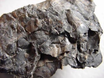
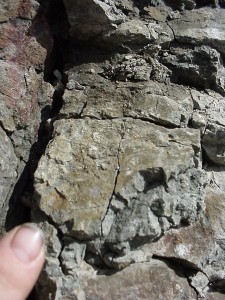
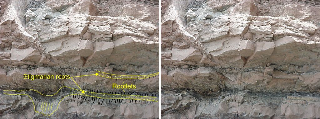
Stigmaria (the roots of Sigilaria) are easily recognizable by the pocks left behind from the rootlets.
The stigmaria grow like this fossil here, with the rootlets radiating out. However, the roots I found were almost always stripped of the rootlets, indicating a violent uprooting. There is the possibility that the rootlets rot off before the roots but I would not know about this. I suspect this is not the case and will go with the more likely explanation, that of a violent uprooting.
One of the few stigmaria I found with rootlets still attached was this one in the MacCarron riverbed:
One interpretation (consistant with the other evidences and the hypothesis of violent uprooting) is that the rootlets held a clump of topsoil together with the root, was violently uprooted and transported elsewhere where it was buried and petrified. The discoloration of the rock immediately surrounding the root is the topsoil that was transported with the rootlets.
Once again, the roots I did find were broken fragments, often stripped of their rootlets which were found in other rocks like some mowed grass.
Conclusions:
There are still many who claim that these polystrate fossils were formed from plants which were growing in situ, and slowly buried, forming these fossil “forests”. However, this is flatly refuted by the evidence. Broken lycopod trunks and chunks, buried at different, cross-secting levels; broken and missing roots; stripped rootlets; inverted lycopods; and vertical (polystrate) lycopods suggest rapid, violent burial by flash flood.
The cross-secting of many strata for many different levels also seems to indicate that at the very least large chunks of the geological strata were laid down virtually simultaneously.
With the exception of two compressed sea bed strata, I see no reason (other than the sheer scale required of such a flood) not to believe that the whole 2000 or so feet wasn’t laid down together. I have heard some suggest that this formation was made by a series of flash floods over many years. This is certainly a fair suggestion, but we are talking about a remarkable series of events: Enormous flash floods, laying down thirty feet or more of strata, one right after the other for years and years on end (save for two short breaks, each recorded by the two sea-bed strata which would indicate it was underwater during those times).
This also still does not answer the Creationist’s claim that geological strata do not take even tens, let alone thousands or millions of years to lay down enormous depths of strata. Thirty feet or more can be laid down very rapidly – rapid enough to bury and preserve an entire giant lycopod. If that thirty feet was obviously laid down rapidly, what reason is there for me to believe that strata this thick (or thicker) elsewhere in the world represents thousands or millions of years?
It is at least as likely that a world-wide flood as recorded in Genesis made this whole formation in a relatively short amount of time, each strata being laid down by enormous tides travelling by the site twice daily. In fact, the two sea bed strata fit the explanation of a global flood better than the hypothesis of many flash floods. The volcanic ash deposits interspersed among the strata would also fit the global catastrophe model as undoubtedly there would have been tremendous volcanic activity going on during this time.
Joggins is a world-class fossil site, utterly unique. It is truly fascinating and mysterious, raising questions in the mind of the inquisitive.
Remaining questions:
Why were the lycopods and calamites buried vertically? We have a model for trees to be buried vertically, as we see happening in Spirit Lake, Mt. St. Helens, Washington, right now. But Joggins is a very unique site – why did giant, hollow reeds get buried vertically and infilled without collapsing? Why is it that the two petrified wood tree trunks I did find were horizontal?
Why do we find animals encased in the bottom of these hollow trunks? Have there ever been any found in the inverted trunks?
I didn’t personally find any, but I have heard reports of slabs of rock with “fossilized mud” which had dried in the sun enough to crack and flake. If this fossil site was caused by a flood, why would we find dried, cracked mud hardened into rock? How long would it take for mud to dry, crack and flake? Is there another explanation for these formations?
ADDENDUM: January, 2003
It has been drawn to my attention that cracks in mud can form underwater.
“Mud cracks (shrinkage cracks) can also originate subaqueously as a result of synaeresis (Jüngst 1934). A rapidly flocculated clay layer develops shrinkage cracks due to compaction (White 1961). Similarly, an increase in salinity can also generate shrinkage cracks in the mud layers (Burst 1965). This process can be important in coastal lagoons and inland sebkhas where salinity of water increases markedly during certain periods. Kuehen (1963, 1965) and Dangeard et al. (1964) also produced underwater shrinkage cracks in the laboratory.
“Such subaqueous shrinkage cracks differ from subaerial desiccation cracks in that they are not so well-developed, the cracks are rather narrow, and they do not possess well-developed V-shapes in transverse sections. In general, subaqueous shrinkage cracks are less regular in form and often incomplete. Sometimes, cracks are developed as open, straight to curved cracks occurring singly or in sets, having a preferred orientation. The cracks are 2-8 cm in length and known as linear-shrinkage cracks. According to Picard and High (1973) linear shrinkage cracks develop when relatively thick water-saturated thixotropic muds dehydrate usually under standing water. ”
(Depositional Sedimentary Environments. Second Edition. Springer-Verlag, New York. 1980 p.60).
Once again, what appeared at first to be evidence of long periods of time adds at least as well into the hypothesis of a massive flood.
I have also come across a claim of a creek bed eroded into strata and preserved by infilling. Lack of strata erosion has always been cited Creationists to claim that strata do not take long periods of time to form. If this is in fact an eroded stream or creek bed, this is the first of its kind in the world that I personally have ever heard of. If true, why is it here? This entire site loudly proclaims rapid formation, burial and upheaval. This seems the most backward place to find such a unique feature. Is this strata vertically cross-sected by any fossils?
Over the past three years I have documented upwards of around 40 trunks in total. As previously mentioned, it was often difficult to see large trunks literally five feet in front of you. I spotted probably around another five “artifacts” which were high up and may or may not have been fossil trees.
Most pictures on this page are links to the full-resolution digital photo.
Four trees (both were actually petrified wood) were found horizontally. Two are in the back of a cave at the bottom of Coal Mine point. I didn’t photograph them, however one of the the more interesting ones is shown here:
I had been told from more than one reliable source that the bark on this tree, up until 1998, was not yet petrified. Although fascinating as always, most people don’t realize that although rare, this is not unique. There have been many fossils over the years found semi-petrified or preserved due to climatic conditions or other reasons. However, this does strain the credibility of the claimed 300 million years of age for the rock this tree was found in. In June of 2003 I was shown a petrified tree in northwestern Colorado that was coalified at the top, petrified at the middle, and wood at the bottom. This was in Cretaceous ash, right alongside dinosaur bones. All three states of preserved wood. In October of 2004, I personally examined another log in the badlands of Alberta, again amongst dinosaur remains. It too was coalified on top, petrified in the middle, and peat at the bottom.
This tree was on the beach, in situ, near the old bridge at MacCarons river, point 17 on the Map . There was a second one nearby, coming out of the cliff.
The Polystrate trees:
Joggins certainly lived up to its reputation with regards to polystrate trees. Here is a sample of some of them, with comments where approrpriate. Point locations are indicated on the Original Map . These are the photos from the original 2002 study.
Polystrate tree cavity, point 5
Polystrate tree, point 6
Polystrate tree, point 7
Polystrate tree, point 13
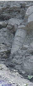
Polystrate tree, point 10 (lycopod and tree-top cavity cut through some 22′ of strata)
Polystrate tree, point 1 (immediately across on your left at bottom of stairs) 50 cm ruler for scale. This one was gone in 2003.
Previously I had carefully laid out how many had root systems and which ones did not. The rate of erosion on the cliffs was very surprising, and in the following year a number of the aforementioned stumps had roots exposed that were not visible the year prior. As was pointed out to me after I left the first year, sometimes the roots are there, but crushed incredibly thin, as can be seen in this example:
This lycopod became exposed in 2003.
This shoes the root loosely outlined.
However, as you have seen, there are stumps which can be clearly studied which have been clearly truncated – the roots are gone. (i.e., photo from “point 10”, shown above). In fact, the entire fossil story embedded in these cliffs is clearly one of chaos: The plants were broken and crushed. Many were strewn all over the place and lapped all over each other when found horizontal.
The roots of the plants are important, as they would indicate in-situ growth. But before we address this further, I should bring up one startling find that affects the study of the roots:
Inverted polystrate trees:
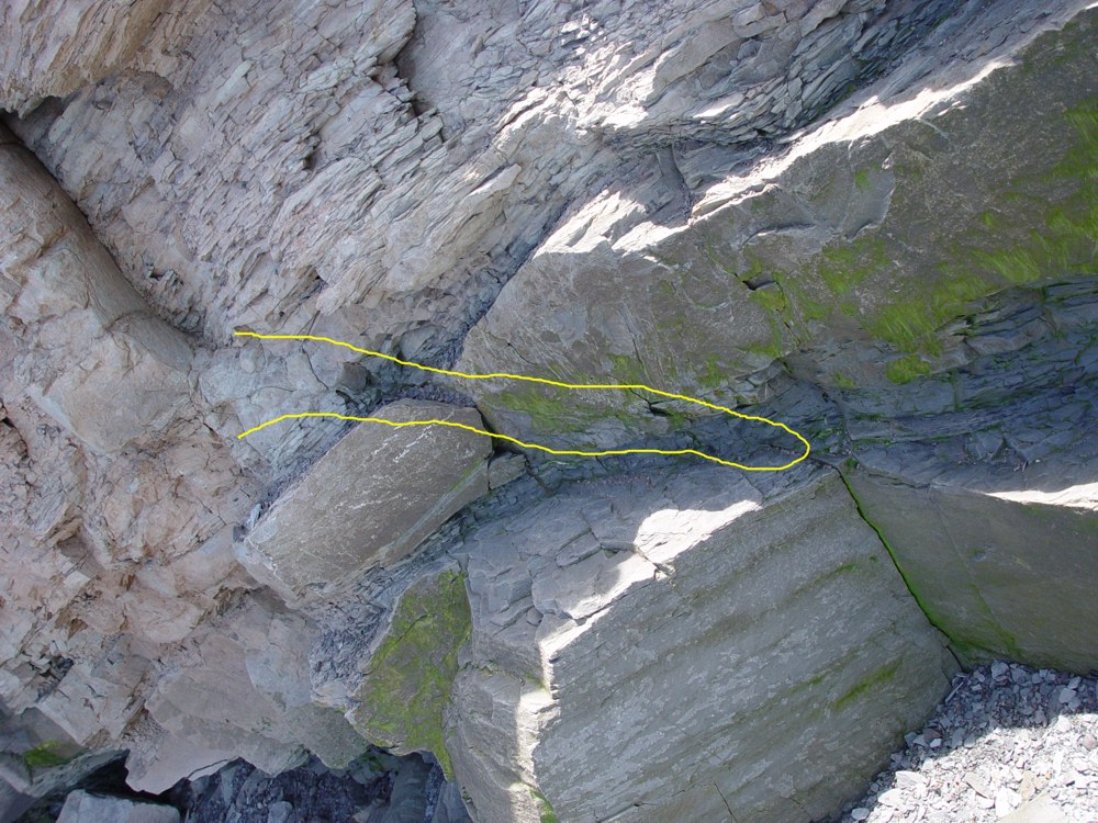
I had heard rumours of some polystrate trees being found inverted, that is buried upside down, but had never seen any photos. After spending three days there and looking for them all the while, I finally found two which were staring me in the face the whole time.
One look at the picture and you can quickly see why it was so hard to spot. The lycopod had fractured vertically, down the middle, flush with the rock face. What you are left with is the outline (roughed out in yellow) and the infill. Remembering that this was a giant, hollow reed the infill is the mud and debris that was packed into the hollow core of the plant when it was buried, later hardening into the rock infill as the plant petrified.
It was definitively identified as a lycopod by the bark which was still embedded in the back half of the fossil. The red arrow marks the spot where I photographed one piece of petrified bark . The bark was protruding from the rock face in several areas and one could follow what appeared to be root stems.
I could not verify for sure that they were root stems without excavating, which could not be done without a permit. However they did appear to be root stems and not branches.
Click here or on the photo to see the full-resolution original without highlights. This fossil was located at point 14 on the map .
Sadly, in the brutal winter of 2003, the following find fell off the cliff and now lays at the base of the cliff in a pile of rubble.
This was north east of the entrance, tucked away around the first corner and about 20 feet off the ground (point 3 on the map).
Twin butted polystrate trees
Previously I had documented this as two polystrates, a fossil trunk and a cavity of a fossil trunk, both stumps and their roots are outlined roughly in green. The bottom stump was inverted. The red outlines mark two stigmaria (the roots of a lycopod). The left one did not appear to be associated with anything visible, and the one on the right appeared to be going up in a “Y”, so I had ruled that out as the origin of the lower stigmaria.
However, in the following year, erosion had revealed that indeed this stigmaria did come from the top stump. Instead of it Y’ing, it was merely crushed in the same fashion as so many other stigmaria found here.
Unfortunately, because at the time I was focusing on the longer root, I had basically ignored the smaller one radiating to the left from the inverted stump. This one definitely was associated with the stump, but it too had fallen off the cliff the following year and I could not re-photograph it. This, combined with the overall shape of the cavity is a dead give-away. It is an inverted stump.
Coffin also documented an inverted stump in Sydney, Nova Scotia (part of the same formation).5
The lycopods, before being destroyed in 2003:
Inverted stumps raise serious, unanswerable questions for the in-situ hypothesis.
Because of the interaction of the strata between the two lycopods, there is a total of about 10 to 12 feet of vertically cross-sected strata. These plants were laid down quickly, and violently.
Broken and missing roots:
This is one of the trunks which exhibits clear root systems, though most of the roots (if there is any more) are hidden in the rock. This one was probably about 30 feet off the ground. All total, I have probaby round about 10 trunks with intact root systems.
In the first year, I found five trees whose bottom end or both ends were hidden in rock or mud washed down from the top of the cliffs. The inverted trees throw a small monkey wrench into things in that the roots aren’t necessarily on the bottom of the fossil trees anymore. Nevertheless, here are four trees whose root systems and/or possible inversion could not be examined or verified, the fifth will be shown in the next page.
Polystrate tree, point 13
Point 16 50 cm ruler for scale
Long view
close-up showing the incredible detail preserved in some of these fossils Point 13
In 2004 I received a surprise:
This is the only intact prostrate trunk I have seen. While there are many prostrate lycopods, they are always crushed flat. This is pertinent for consideration when attempting to model how Joggins was formed.
This prostrate log also had intact roots which had clearly been ripped up along with the trunk:
The cliffs of Joggins, Nova Scotia, Canada have become quite famous in Creation/Evolution circles. Besides being a fantastic fossil site, they have attracted interest by their polystrate “trees”. These trees are actually giant lycopods (refering to the last two science notes, we discussed fossil giantism and specifically mentioned lepidodendrun, a Lycopod), up to a meter in diameter. These trees, and other trees were found layered horizontally in the strata, as well as cutting through several strata vertically. This was first observed and still believed by many to be trees which were buried and preserved in situ (in place) as they grew.
Debate has ensued over whether these were trees in situ or not. Creationists have pointed out that the bottom of the tree obviously isn’t thousands or millions of years older than the top of the tree, as would be suggested by the many layers of strata they sometimes cut through. (strata, or layers of rock, are believed to take long time periods to be laid down) Others had cited fine root systems as obvious evidence of the trees being buried in place. I had heard other reports of trees being buried vertically – upside down! I had heard of animal skeletons being found in the stumps and the theories surrounding this discovery seemed to me to support the long periods of uniformitarianism.
For a lot of these reports and discoveries, I was presented with little or no evidence I could examine for myself. In particular, photos were one thing I had hoped for.
So being the kind of person that wants answers and likes to draw his own conclusions, I decided to go and study the cliffs for myself, documenting them photographically to be shared with others who also like to draw their own conclusions.
I spent six days at Joggins, studying and documenting roughly five kilometers of cliffs. The next few “science notes” will be dedicated to a presentation of that documentation and my findings. Later on, probably in 2002, I will be returning to the cliffs as some other features have since been pointed out to me which I missed while there. There will be a future addendum to this study.
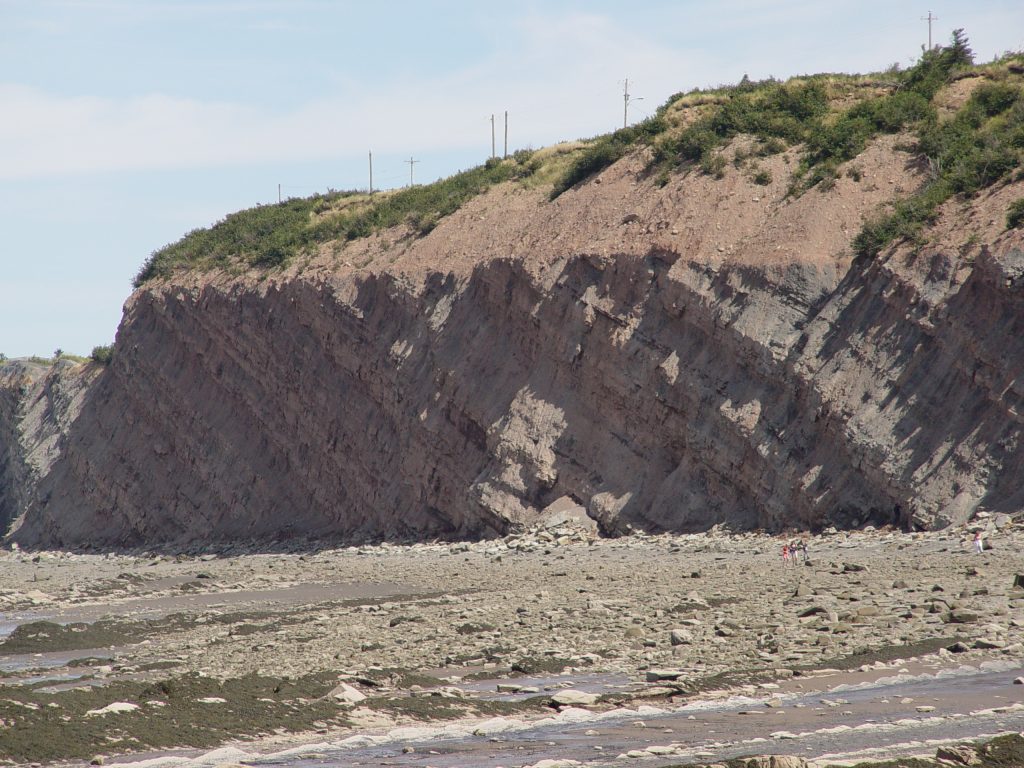
The Cliffs:
I strongly encourage you to visit the cliffs if you get the chance. However, take a few tips from ‘ol Ian:
The cliffs are exposed to tides as high as 45 feet or more, twice daily. Refer to tide charts and plan on heading there from about three hours before low tide. If you get caught by high tide, it’s not the end of the world, but you do get wet and you do get trapped against cliffs that you don’t necessarily want to be hanging around too close to either. The tide steadily erodes the cliffs which makes for excellent fossil viewing as new fossils are exposed constantly. However, this brings up other problems such as…
The beach in many areas is covered in loose, shattered boulders which are underwater twice daily and thus very slippery. Use extreme caution in these areas as one slip of the foot can break bones, crack skulls and cut thus promptly limiting your fossil studies to internet surfing from your hospital bed.
The cliffs are constantly shedding rock. The problem I encountered was that I needed to get close to the cliffs to perform my study, however you are constantly showered with pebbles and sometimes rocks. I saw several large rock slides during my time there. A helmet is a very good idea but stay away from the immediate vicinity of the cliffs unless you need to be there. In particular, there are excessive rockfalls on hot days, cold days, rainy days, windy days and hoo boy, better watch out for it on those spring days.
Please note: These cliffs are a fossil heritage site and you are not allowed to remove fossils or rock from the cliffs without a heritage research permit. Fossils on the beach are fair game. (For the moment)
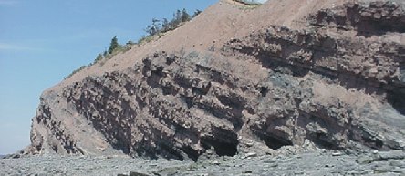
Joggins is located about 20 minutes out of Amherst, on the Bay of Fundy.
The cliffs are made up of various solid rock and conglomerates interspersed with layers and levels of volcanic ash, coal and compressed sea bed. The strata are generally tilted to the west, typically on about a 30 degree angle but it varies.
Map of Joggins fossil cliffs
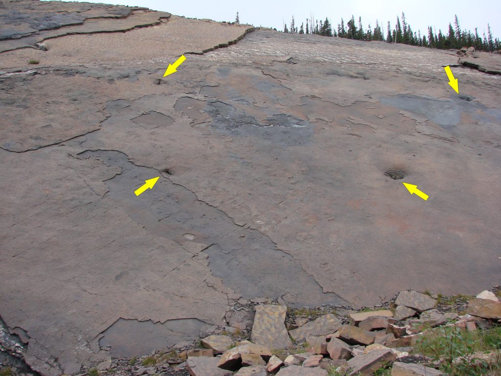
All total, there was approximately 600 meters (~2000 feet) of strata represented from point A to point B, the total area of this study. 1 All five kilometers had sparse to densely populated exposures of polystrate lycopods and calamites. The stretch from point A to McCarron’s river was divided roughly into thirds by two single strata (Points 9 a & b) of compressed sea bed conglomerate, varying in thickness around the 16″ mark.
Fossils in the cliffs were often very difficult to spot for a number of reasons. Mud and gravel washed down the face of the cliff during rainfall would harden and obscure even huge fossil trees. The fossils themselves of course have also taken on the colour of the surrounding rock, making them very difficult to spot. Most of the “trees” were of course, hollow reeds (lycopods, calamites or fossil horsetail) being infilled with the surrounding sediments which later petrified. The trees or reeds would sometimes break apart vertically and flush with the rock face, making the thin outline of the fossil very hard to spot.
The beaches themselves were littered with fossils. Primarily calamites and lycopods, there were also fossil ferns, and trackways. The sea bed congolmerations would contain uncountable multitudes of fish scales and various sea shells as well as small bones.
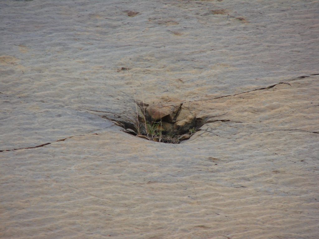
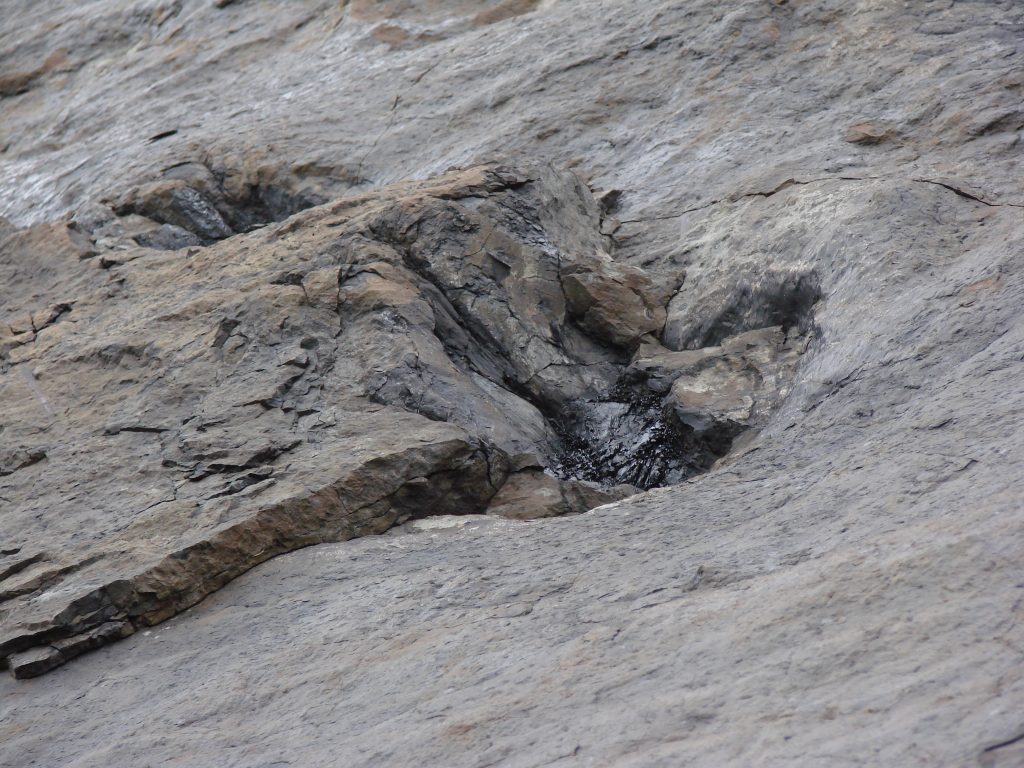
“Reefs” stretched out into the bay, the remnants of various strata which had not succomed to the erosion. These too of course contained fossils, including polystrate trees of which I found at least one.
Continue to part II: The fossil “trees”
Part III: Interaction of strata and fossils
I received an email asking some common questions about polystrate fossils. To my dismay, I realized I had never actually answered these questions in writing anywhere.
Polystrate fossils are fossils which are buried in the sedimentary record cutting through more than one sedimentary layer. The rock layers are called ‘strata’ and the fossil cuts through more than one, hence the name ‘poly’ for many and ‘strate’ for the strata the fossil cuts through. Polystrate fossils are found literally all over the world.
This fossil plant (a type of plant called a Lycopod) buried vertically cutting through layers of rock at Joggins, Nova Scotia is a classic example of a polystrate fossil.
Polystrate fossils create an impossible situation for advocates of deep time. Clearly the rock layers have not been laid down over millions of years as the top of the trunk would have rotted away long before the layers were deposited. Yet the father of deep time, Sir Charles Lyell, still advocated that these plants were buried where they grew (‘in situ’) in order to bolster his ‘new history’ of deep time he invented to replace the Biblical story of a global flood. A gentleman by the name of Paul wrote in some questions regarding polystrate fossils:
Dear Mr. Juby,
I am writing with a question about polystrate lycopod fossils. I was tipped off that I should ask you about these because I saw an image on creation.com of one such specimen which had been attributed to you. I have searched through a bit of creationist literature and have thus far not been able to find any decent scientific sources to refute the skeptic’s claim that these polystrate tree fossils must have been buried in situ because they have intact root structures that grew into the surrounding strata. I have seen a couple of creation articles claim otherwise, but I didn’t find any suitable references to back up this claim. On the contrary, I was provided by a skeptic with a reference to a very old book from the 19th century that purports to describe them thus: “One of the most remarkable peculiarities of the stigmaria-rooted trees was the very regular arrangement of their roots, which … divide at equal distances … giving off, on all sides, an immense number of rootlets, stretching into the beds around, in a manner which shows that these must have been soft sand and mud at the time when these roots and rootlets spread through them … the roots found in them were not drifted, but grew in their present positions;”
Do your own observations contradict this description? Is this description even referring to the same thing as what creationists are referring to when they talk about polystrate trees? Wading through this mess is proving difficult, so I would be glad to receive any clarification or help you might be able to provide.
Acadian Geology, John William Dawson, Third Edition, MacMillan and Co., London, 1878
Excellent questions that I hear fairly regularly. It is true that there is often intact roots found attached to these fossil stumps. I have photos of dozens of such cases. Lyell’s argument (as well as Dawson and the modern day deep time advocates) is that the intact roots are evidence that they were buried where they grew. The fact that in general, the stumps with intact roots tend to be found on the same clay bedding plane further bolstered the claim that the bedding plane was the original forest floor which was also buried in place along with the trunks.
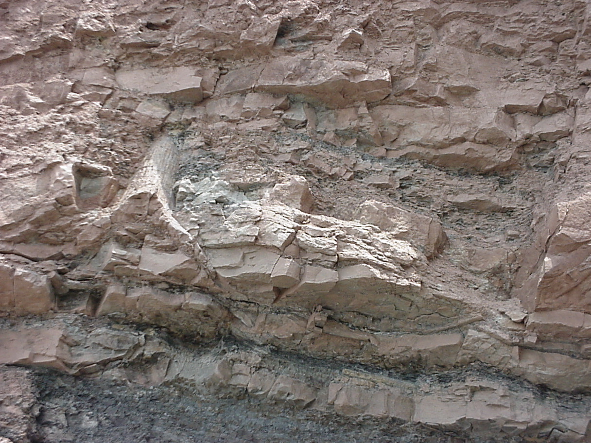
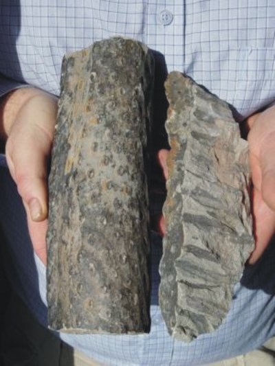
In the photo below you can see a chunk of one of the roots (commonly called stigmaria) and you can see the pock marks around the outside, each of which radiates a rootlet. The rootlets are visible in the counter slab as black marks as the roots, rootlets and plants have all now turned into coal.
It should be noted that these plants are still around today as the Lepidodendron. Today those plants grow to maybe 16 inches tall, yet in the fossil record they are found up to 120 feet tall. The roots and the trunks are actually hollow, although the trunks had a pithy core which was displaced and infilled with sediments when the trunk was buried.
The stumps are sometimes found with the rootlets and/or roots stripped from the trunks. Clear signs that the trunks were ripped up by water, transported a distance and buried, refuting the idea of ‘in situ’ burial. But let us remember that polystrate fossils are a global phenomenon that includes far more than just the lowly Lycopods. For example, polystrate fossil coprolite (fossil poo!) has been reported at the public fossil dig sites in the Green River formation of Wyoming. Solid wood polystrate fossil tree trunks have been found in multiple places like Yellowstone National Park, or Axel Heiberg Island in the Canadian arctic. Interestingly, the ‘fossil’ stumps of Axel Heiberg Island aren’t fossilized – you can cut them with a hand saw and burn them. I have samples of this wood in my museum collection and these samples were included in the Carbon 14 testing conducted by Thomas and Nelson(1) and low and behold, there was lots of C14 found in them. But I digress. In the entire, exhaustive report by the Geological Survey Of Canada(2) on the alleged ‘in situ’ fossil forests of Axel Heiberg, you are hard pressed to find any stumps with intact roots! You will find one stump with roots extending a whopping 3 feet to a root end which has clearly been broken off. Yet these stumps are referred to consistently as buried ‘in situ.’ This is what is typically found in these alleged ‘in situ fossil forests’ claimed by advocates of deep time, so clearly their definition of ‘in situ’ and ‘intact roots and root systems’ are quite a bit different from mine!
Furthermore, the claim that the trunks of Joggins are all rooted in clay horizons (as implied by Dawson in Acadian Geology and reiterated by many deep time advocates) is demonstrably false. At the Joggins fossil cliffs the roots will be found in just about any form of deposit: clays, sandstones, shales, even coal seams. The polystrate Lycopods at the Wartburg, Tennessee coal mine were ‘rooted’ in the same horizon which was a coal seam. The polystrate trunks found in the Grande Cache coal mine (which we’ll look at closely in just a moment) were also rooted in the same horizon, a coal seam.
But let’s give the skeptics the benefit of the doubt: let’s assume that all of the stumps have intact, complex root systems in the same horizons. The roots of multiple trunks sharing the same horizon is actually not good evidence for in situ burial. Especially when one takes a closer look at those roots and their alleged ‘forest floor.’
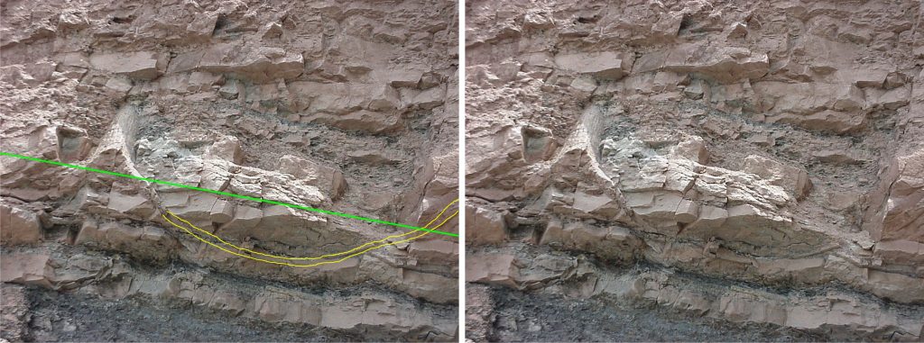
Clearly visible roots apparently ‘floating’ above what would have been the soil line. The ‘forest floor’ horizon is marked in green.
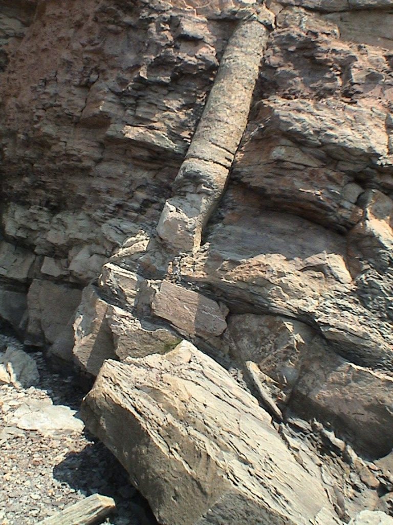
Taking a look at the dramatic Lycopod stump, I’ve highlighted the very long root attached to the stump, complete with rootlets. Notice that the root descends from the stump, then ascends, bending upwards as if floating, and even coming up above what is claimed to be the forest floor horizon! This particular specimen has all the qualifications to meet the definition of ‘in situ’ put forward by the deep time advocates: It has intact roots and rootlets, it shares the same horizon with other stumps and roots, and it was rooted in what is interpreted as a clay horizon. Yet it is unlikely that the roots would have grown in this way – the roots grow down, not up. However, if this stump had been dislodged and transported by water, the roots would have been buoyed up in the sediments and water, thus we have an excellent explanation for this bizarre phenomenon. But – it gets better. The roots of that stump are actually entangled with the roots of a second stump which is underneath the first. The second stump is buried upside-down!
I have marked the prominent roots from the upright and inverted stumps. The inverted stump has actually fallen out of the cliff, leaving behind its impression and its root with intact rootlets. The upper stump has a second root coming down (in behind the word “roots”) which was apparently entangled with the roots of the inverted stump.
This second, inverted stump, also has all of the qualifications for the ‘in situ’ definition: intact roots and rootlets, sharing the same horizon with other stumps and roots, and it was rooted in what is interpreted as a clay horizon. But last I checked, plants don’t grown very well upside-down.
While not common at Joggins, I’d probably estimate about 1 in 100 of the polystrate Lycopods are buried upside-down. I am not the first, nor the only one to report these inverted stumps. Geologist John Mackay(3) has found some as well as Harold Coffin who documented some and provided photos of in his excellent book “Origin by Design.”(4)
When I visited the Grande Cache coal mine in 2010 to investigate the copious numbers of fossil dinosaur tracks found there, the young geologist and I made an unexpected discovery. The stratigraphic horizons are tilted up now from tectonic upheaval, almost to the vertical. We kept seeing these strange, star-shaped depressions in the layers.
When we came across one at ground level, we were shocked to find that these were all coalified stumps buried upside-down with their roots coming up into the coal seam (which had been mined away) and the trunk itself going downwards, cutting polystrate through the layers containing the trails of dinosaur tracks.
Telephoto image of one of the inverted stumps. Notice the fossil wave ripples in the sediments.Multiple, inverted, polystrate stumps had their roots in the same horizon, now a coal seam which had been excavated for the coal.One of the inverted stumps at ground level. While I couldn’t identify the plant, it was hollow like the Lycopods.
These stumps (the numbers of which I didn’t count – but as you can see were more than just a few) again fit the stipulations of the deep time advocates for interpreting these stumps as buried in situ: there were intact roots (though they have been removed in the mining operations) attached to the stumps and shared the same horizon with many other stumps. The only problem being, the trunks are all buried upside-down. Clearly these trunks weren’t buried where they grew. It’s also pretty clear that the multiple levels of dinosaur trails were not seasonal migrations as the stumps would have been sticking up from the sediments, upside down, for at least years while the sediments deposited every year for the dinosaurs to walk on. But I digress.
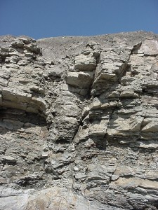
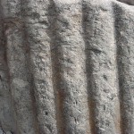
There is another significant argument to be made against deep time and the idea that these multiple horizons of fossil trunks were years of forest growth and burial. Take a look at this lycopod root:
A Lycopod root protruding from the cliff face.
This particular root is interesting for a few reasons. You can see the darker, differentially coloured sediments surrounding the root, as if the rootlets had clumped some soil surrounding the root when it was ripped up by water, transported and buried here. But this root, like all the others here, also tells a story of incredible pressures. The Lycopod roots were hollow and originally round. Notice the root has been squished vertically. The roots were very strong, hollow tubes and almost invariably have been crushed to failure. Although it’s difficult to see in the photo, the roots have not only been flattened vertically, they are actually split from the pressure on the top and bottom.
The sedimentary layers of Joggins total almost 20,000 vertical feet. You can walk miles of beach and because the layers have been tectonically tilted to the south (and then planed off flat across the top – see my CRSQ paper on these Planation surfaces(5)), you can examine thousands of vertical feet of sediments from the comfort of a stroll down the beach.
You’ll find roots throughout the thousands of feet which have all been compressed vertically. You’ll also find fossil logs which have been compressed to incredible levels, such as this one:
One of thousands of compressed and petrified fossil trees. Interestingly, the hollow plants tend to be buried polystrate (unless they were flattened) while the solid wood trees tend to be buried prostrate. Notice the log has been flattened vertically from compression at about 4:1 thickness ratio.
The pressures required to do this are astonishing. We can draw several, simple conclusions: 1) the trees and roots were still green when they were compressed. 2) the trees and roots had not rotted (they are preserved in pristine condition). 3) The trees had not yet petrified when they were compressed because simply put, you can’t compress a rock! 4) The Lycopod trunks and roots all show bending and compression which had to have happened while they were not yet turned to coal – they bent, instead of fracturing and disintegrating as hard and fragile coal would do. 5) The sediments the trees and Lycopods were buried in had not yet lithified (turned to solid rock) as the sediments themselves show compression and deformation along with the plants.
Everyone agrees that the compression was caused by the weight of the enormous overburden of sediments piled on top of the plants. In experiments conducted separately by myself and Vance Nelson (Creation Truth Ministries, Alberta, Canada) we were unable to deliver sufficient hydraulic pressures to mimic the compression we see in the fossil record. In my own experiment, I had pressures equivalent to hundreds of feet of overburden. So let’s play it safe with an unrealistically conservative number and say it requires a mere 300 feet of sediments to crush the Lycopodium tubular roots and the tree trunks. Starting at the bottom of the Joggins formation, we find crushed fossil logs. So a minimum of 300 feet of sediments need to be rapidly piled on top of the log before it rots, while it is still green and compressible, before it turns to stone, and before the sediments turn to stone. But in that 300 feet of overburden you will find many more crushed, petrified and coalified tree trunks and Lycopod roots – all of which also had to have been rapidly buried under a minimum of hundreds of feet of soft sediments before the plants rotted, while they were still green, before the plants turned to coal or stone, and before the sediments turned to solid rock.
But in that 300 feet of overburden sediments required to do this, you will find more crushed logs and Lycopod roots. Ad infinitum. You can put the entire ~20,000 vertical feet of sedimentary layers of the Joggins Formation into one, rapid burial event that accumulated so fast that the plants buried within were still green, had not rotted, had not turned to stone or coal, and the sediments had not yet had a chance to turn to solid rock.
Oh, and did I mention this is consistent with every formation containing polystrate fossils you find around the world?
What kind of event would rapidly bury millions of plants in tens of thousands of feet of sediments over a provincially sized area? I can assure you of one thing: whatever event that would be, we would call it a catastrophe, and on a global scale – not long and slow geological processes. Interestingly, that planation surface at the top of the cliffs is also a pertinent part of the big picture: the layers were eroded by huge volumes of extremely fast moving water. Everything about the Joggins formation in particular (but also attributable to every other polystrate fossil formation you’ll find) speaks of a huge, watery catastrophe of global proportions. I would contend it was the flood of Noah’s day. Yes, there is evidence for Noah’s flood. It’s all around you, and it’s profound and overwhelming.
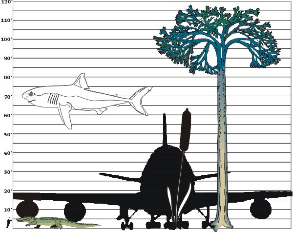
I’ll finish up from the last article with a few more giants from the past (the ones that wouldn’t fit on the last chart!).
Once again, down in the bottom left hand corner is a man standing roughly 6 feet tall for scale. Since he is no longer good enough to provide scale, I’ve thrown in a scale sized 747 Jumbo jet silhouette for fun.
Please note first off in front of the 747 nose is a cattail – a bull rush. Growing today usually 3 to 6 feet tall, in the fossil record they are found growing up to 60 feet tall!1
About to have the man for dinner is Sarcosuchus Emperitor, dubbed the “Supercroc”. A crocodile some 45 feet long.2
Recently I returned from the famous Joggins cliffs in Nova Scotia, here in Canada. While there I was able to see and photograph first hand some of the species of plant found towards the right of the chart, Lepidodendrun. The cliffs have different species of lycopods such as Lepidodendrun and Sigilaria. Their modern day counterparts are the club moss, which today grows about 16 inches in tropical conditions.
Sigilaria, shown here, grew up to almost 100 feet tall. Here is a smaller one, roughly 70 cm at the base. They have been found at Joggins up to a meter at the base.
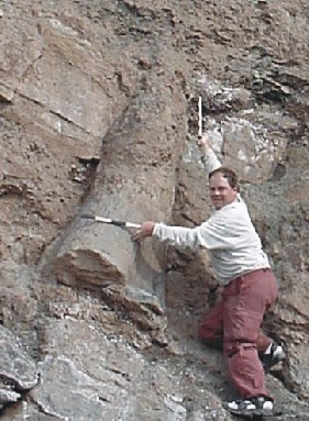
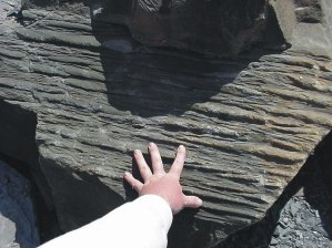
Although I didn’t find any large, intact Lepidodendrun, I did find this rather large chunk of fossilized bark from one. My hand is in the photo for scale but clearly it was considerably larger in the past.3
And last but not least on our chart is Megalodon.4Megalodon was a shark arguably between 50 and 100 feet long. You might think that that is a rather large margin of error. It is. You see, that is because it is difficult to tell the size seeing as how shark skeletons are made of cartilage and hence decompose rather than fossilize. We can estimate their size however by their fossil teeth which we do find. I’ve shown the one in our chart at roughly 75′ to compromise.
We will discuss this subject in more detail in the future and venture into proposed explanations for this bizarre phenomena.
References / footnotes:
1. Personal communication, Dr. Carl E. Baugh, director, Creation Evidences Museum, Glen
Rose, TX [Return]
2. On line resources: www.supercroc.org [Return]
3. On line resources and references: Nova Scotia Museum of Natural History [Return]
4. There are loads of resources and references pertaining to Megalodon, merely visit your library or do an internet search. [Return]
 In the same respect, these giant horsetails (again, a reed, and one that still exists today in a much smaller form) are located at site 2, just Northeast of the stairway entrance.
 Although only cross-cutting about eight feet worth of strata, it is important to note that these plants were buried within a short amount of time of each other, or at the same time in one giant slurry of mud.
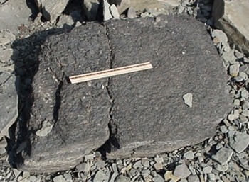 .
. 
 But it would have to harden quickly or else the tracks would be lost to erosion.
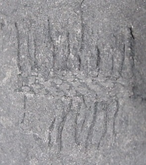 The roots (as well as the lack thereof) tell a very specific story. As I have already mentioned, very few of the plants actually had root systems. Of those, many were broken roots and/or roots with the rootlets stripped off of them.
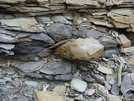 One interpretation (consistant with the other evidences and the hypothesis of violent uprooting) is that the rootlets held a clump of topsoil together with the root, was violently uprooted and transported elsewhere where it was buried and petrified. The discoloration of the rock immediately surrounding the root is the topsoil that was transported with the rootlets.
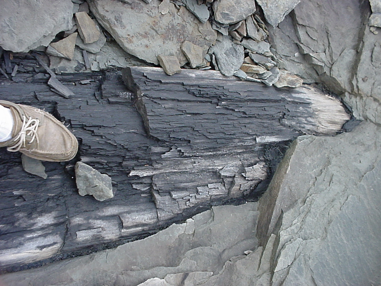


 Debate has ensued over whether these were trees in situ or not. Creationists have pointed out that the bottom of the tree obviously isn’t thousands or millions of years older than the top of the tree, as would be suggested by the many layers of strata they sometimes cut through. (strata, or layers of rock, are believed to take long time periods to be laid down) Others had cited fine root systems as obvious evidence of the trees being buried in place. I had heard other reports of trees being buried vertically – upside down! I had heard of animal skeletons being found in the stumps and the theories surrounding this discovery seemed to me to support the long periods of uniformitarianism.
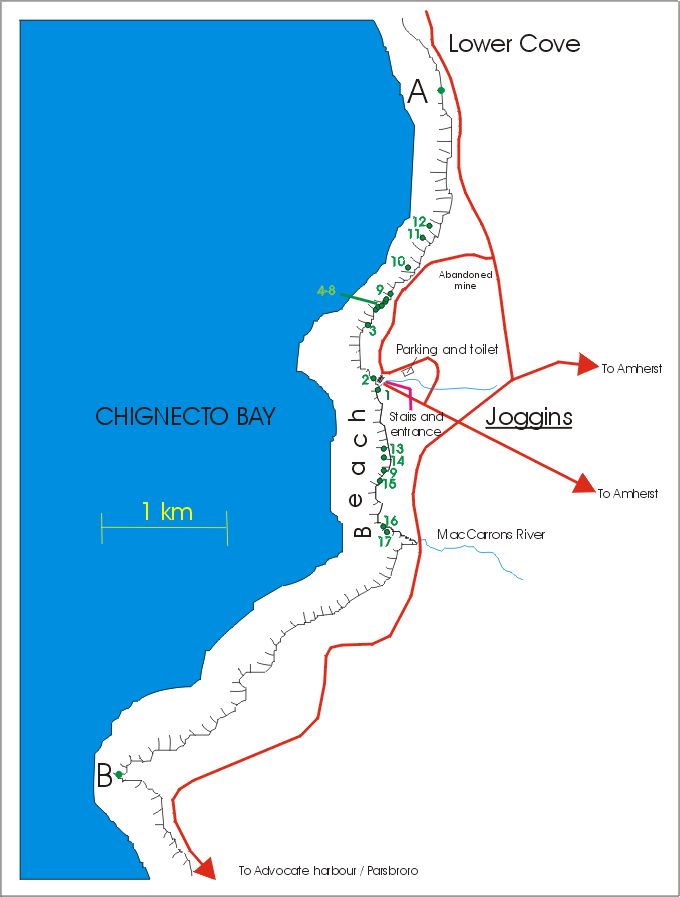


 And last but not least on our chart is Megalodon.4Megalodon was a shark arguably between 50 and 100 feet long. You might think that that is a rather large margin of error. It is. You see, that is because it is difficult to tell the size seeing as how shark skeletons are made of cartilage and hence decompose rather than fossilize. We can estimate their size however by their fossil teeth which we do find. I’ve shown the one in our chart at roughly 75′ to compromise.